Scientific Mechanisms
Evaporation Buffering
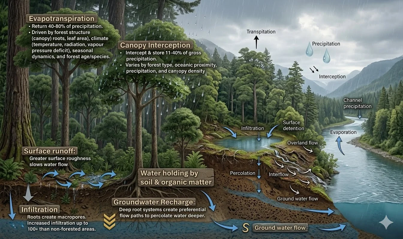
Dense, multi-layered native vegetation reduces surface evaporation through three reinforcing mechanisms: canopy shade reduces the solar energy reaching bare soil; wind buffering by tree and shrub layers reduces convective moisture removal from the soil surface; and the organic litter that accumulates beneath established plantings acts as a physical mulch, slowing direct soil-atmosphere moisture exchange. Together, these mechanisms are projected to reduce surface evaporation by 35–50% within established project zones — retaining significantly more moisture in the soil profile for plant use, groundwater recharge, and streamflow.
The Biotic Moisture Pump
A mature cottonwood tree transpires 50–100 gallons of water per day during the growing season. When 500,000 trees transpire simultaneously across a 30-mile corridor, the cumulative effect is a measurable addition of moisture to the local atmosphere raising relative humidity by an estimated 5–10%, reducing vapor pressure deficit at canopy level, and creating more favorable conditions for seedling survival, soil moisture retention, and snowpack persistence. This biotic moisture pump effect, documented in the peer-reviewed literature by Ellison et al. (2017) and Makarieva et al. (2014), transforms the corridor from a collection of individual trees into a self-reinforcing ecological system that actively maintains the moisture conditions its own health depends on.
Wildfire-Resilient Landscape Design
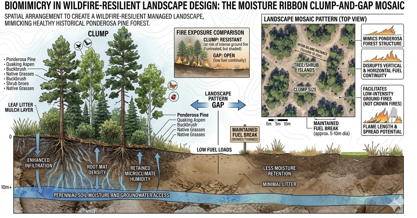
The Moisture Ribbon is not planted in continuous rows — it is designed as a mosaic of clustered tree and shrub islands separated by maintained fuel breaks, mimicking the clump-and-gap structure of healthy ponderosa pine forest that historically survived frequent low-intensity fire. Species diversity distributes fire risk across fuel types with different moisture contents and combustion characteristics. Maintained fuel breaks at corridor edges and access roads provide defensible ground for fire management. The result is a landscape that is both more resistant to catastrophic fire and more resilient in recovery when fire does occur.
The Solution: The Moisture Ribbon
The North Front Range Moisture Ribbon Project does not propose to address these crises incrementally. It is designed to address them at the scale the crises demand — 30 miles, 500,000 to 750,000 native trees and shrubs, 3,000+ acres of restored forest and riparian corridor, and a monitoring system rigorous enough to verify every projected outcome.
The North Front Range Moisture Ribbon Project is a conceptual, science-driven initiative led by Joyful Earth Stewards Using Sustainability (J.E.S.U.S.), which is actively seeking to work in direct partnership with the Colorado State Reserach Departments, Academic Insitutes and Land Conservation. The goal is to engage these as core technical partners to provide expertise in native species selection, local provenance seedling sourcing through their Fort Collins nursery, and the design of monitoring protocols to ensure restoration concepts meet the highest ecological standards. This envisioned partnership is intended to ensure that every phase of the Moisture Ribbon from species selection to field monitoring reflects both the best available science and Colorado's long-term stewardship priorities.
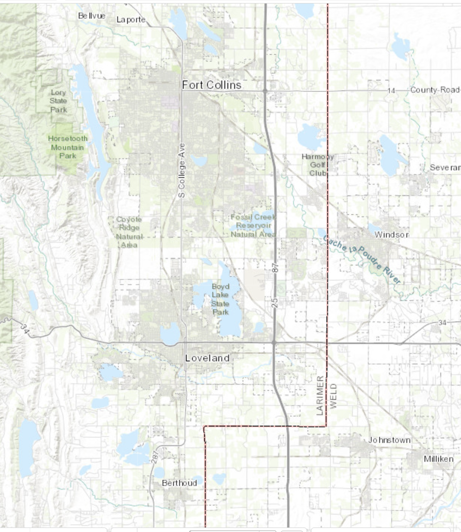
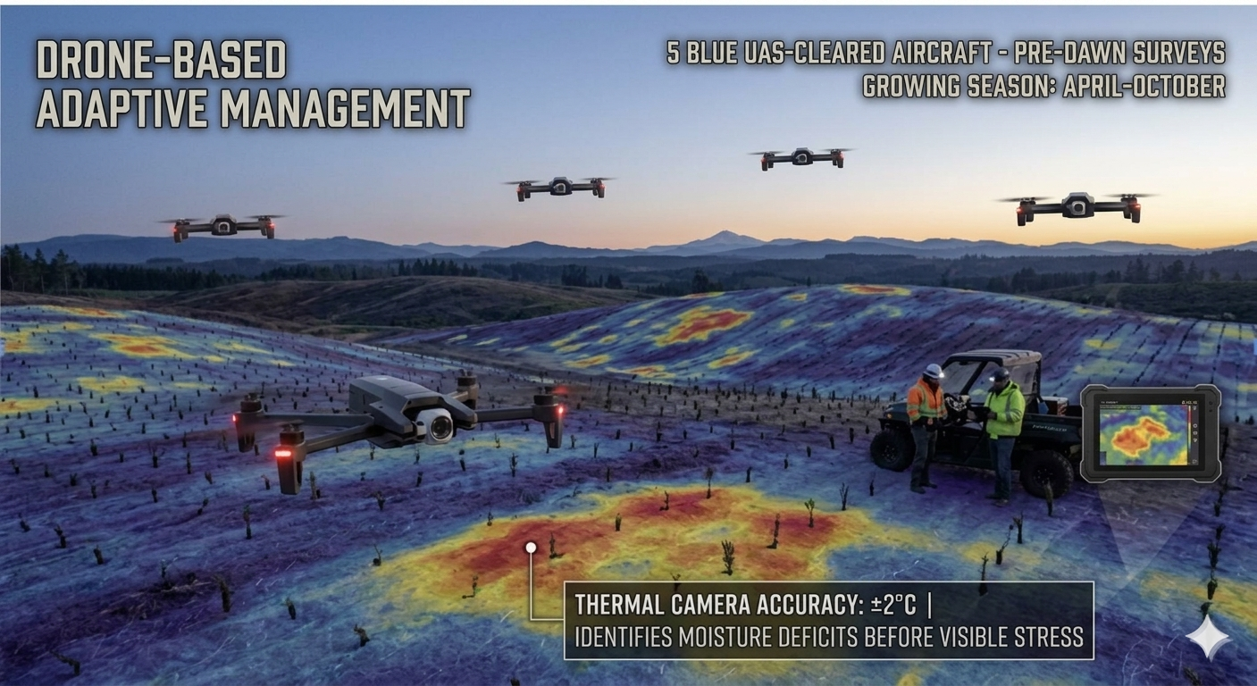
The proposed Moisture Ribbon is envisioned as a precisely engineered ecological system extending from Bellvue in the north near the southern edge of the Cameron Peak burn scar to Hygiene in the south, where the corridor would terminate at St. Vrain Creek. Under this proposed framework, every site would be selected through GIS analysis, soil assessment, and fire history review. Every species would be matched to micro-site conditions, elevation band, and ecological function. The intended structure includes providing every seedling with two years of active biweekly irrigation, protective tree tubes, stakes, and mulch rings. Additionally, the plan looks to track every tree in real time through a LoRaWAN wireless sensor network and a fleet of five U.S approved thermal drones that would fly pre-dawn surveys every morning during the April–October growing season — identifying moisture deficits before visible stress appears in seedlings to direct water truck delivery to exactly where it is needed.
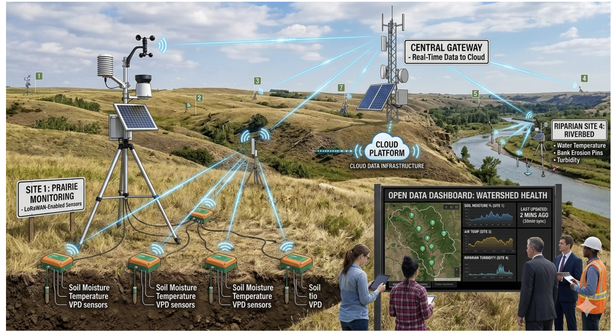
Real-Time Sensor Network
At full corridor scale, the Moisture Ribbon will deploy LoRaWAN-enabled environmental sensors across every site, transmitting soil moisture, soil and air temperature, relative humidity, and vapor pressure deficit to a central cloud platform. At riparian sites, additional sensors will monitor stream temperature, bank erosion, and turbidity. Data will be published on a public Open Data Dashboard, giving donors, funders, researchers, and regulators direct access to every metric the project tracks.
Continuous Environmental Monitoring
Every J.E.S.U.S. restoration site will be instrumented as a living laboratory. At our first prototype site, a network of sixteen sensor nodes will log soil moisture, soil temperature, air temperature, and relative humidity at fifteen-minute intervals across four hydrologic zones — from the saturated riparian belt at the river's edge to the dry upland buffer.
From that data we will calculate Vapor Pressure Deficit: the atmospheric drying pressure acting on every leaf. It is the measurement at the center of our work.
Two additional nodes will sit in an unplanted control zone nearby. This is what makes the design scientific rather than anecdotal — we compare the restored ground not only against its own pre-planting baseline, but against untouched ground experiencing the same weather on the same day. Seasonal variation cannot masquerade as restoration effect.
Data will move off-site over a low-power wireless network to a public dashboard, so anyone — funder, partner, or neighbor — can watch the corridor breathe in near-real time.
What the data will do
Continuous monitoring means the field team sees moisture stress developing days before it becomes visible in a seedling. Irrigation is directed by evidence rather than by calendar. Automated alerts flag drought and saturation thresholds so a crew can respond before plants are lost, not after.
The Biotic Moisture Pump — The Hypothesis We're Testing
A mature cottonwood transpires 50–100 gallons of water per day during the growing season. The biotic pump hypothesis — advanced in the peer-reviewed literature by Ellison et al. (2017) and Makarieva et al. (2014) — holds that forests do not merely respond to available moisture but actively participate in moving and maintaining it.
Whether that effect appears at the scale of a 30-mile corridor is an open question. It is contested in the literature and it is scale-dependent. We are not asserting the answer; we are building the instrument to find it.
That is what the Moisture Ribbon is: a corridor engineered so the question can be tested honestly, against a control, with data anyone can inspect.
Independent Scientific Review
An Annual Scientific Review Panel—envisioned to feature faculty and researchers from regional universities and federal research stations—would evaluate corridor performance data, assess outcomes against projections, and recommend adaptive management adjustments. Findings would be incorporated into an Annual State of the Ribbon Report, which would be published publicly and distributed to all partners, funders, and stakeholders.
All proposed monitoring protocols — including LoRaWAN sensor deployment, field audits, and adaptive management procedures — are intended to be developed in consultation with state forestry and land authorities to ensure all methods align with state and national restoration standards. Academic representatives would be invited to participate in the Annual Scientific Review Panel to provide independent oversight and technical validation of project results..